

SPC Severe Thunderstorm Watch 291
WW 291 SEVERE TSTM KS NE 090130Z - 090700Z


URGENT - IMMEDIATE BROADCAST REQUESTED
Severe Thunderstorm Watch Number 291
NWS Storm Prediction Center Norman OK
730 PM MDT Mon Jun 8 2026

The NWS Storm Prediction Center has issued a

* Severe Thunderstorm Watch for portions of
  Northwest Kansas
  Western and Southwest Nebraska

* Effective this Monday night and Tuesday morning from 730 PM
  until 100 AM MDT.

* Primary threats include...
  Scattered damaging winds and isolated significant gusts to 75
    mph possible
  Isolated very large hail events to 2 inches in diameter possible
  A tornado or two possible

SUMMARY...A mix of supercells and clusters should continue to pose a
threat for occasional large hail and scattered severe/damaging winds
up to 60-75 mph as they spread generally eastward this evening into
the early overnight hours. A tornado or two may also occur with
line-embedded circulations.

The severe thunderstorm watch area is approximately along and 60
statute miles east and west of a line from 50 miles east southeast
of Goodland KS to 65 miles west northwest of North Platte NE. For a
complete depiction of the watch see the associated watch outline
update (WOUS64 KWNS WOU1).

PRECAUTIONARY/PREPAREDNESS ACTIONS...

REMEMBER...A Severe Thunderstorm Watch means conditions are
favorable for severe thunderstorms in and close to the watch area.
Persons in these areas should be on the lookout for threatening
weather conditions and listen for later statements and possible
warnings. Severe thunderstorms can and occasionally do produce
tornadoes.

&&

OTHER WATCH INFORMATION...CONTINUE...WW 287...WW 288...WW
289...WW 290...

AVIATION...A few severe thunderstorms with hail surface and aloft to
2 inches. Extreme turbulence and surface wind gusts to 65 knots. A
few cumulonimbi with maximum tops to 500. Mean storm motion vector
27030.

...Gleason


Read more
SPC Severe Thunderstorm Watch 290
WW 290 SEVERE TSTM KS 090030Z - 090600Z


URGENT - IMMEDIATE BROADCAST REQUESTED
Severe Thunderstorm Watch Number 290
NWS Storm Prediction Center Norman OK
730 PM CDT Mon Jun 8 2026

The NWS Storm Prediction Center has issued a

* Severe Thunderstorm Watch for portions of
  Central and Eastern Kansas

* Effective this Monday night and Tuesday morning from 730 PM
  until 100 AM CDT.

* Primary threats include...
  Widespread damaging winds and isolated significant gusts to 85
    mph likely
  Scattered large hail and isolated very large hail events to 2
    inches in diameter possible
  A tornado or two possible

SUMMARY...Supercells should continue to transition and grow upscale
into an intense bowing cluster this evening. Occasional large to
very large hail and perhaps a tornado or two will remain possible
with any thunderstorms that can remain at least semi-discrete.
Otherwise, numerous to potentially widespread severe/damaging winds
appear likely with the bowing complex. Peak gusts may reach up to
75-85 mph on an isolated basis.

The severe thunderstorm watch area is approximately along and 50
statute miles north and south of a line from 25 miles north
northwest of Salina KS to 35 miles southeast of Topeka KS. For a
complete depiction of the watch see the associated watch outline
update (WOUS64 KWNS WOU0).

PRECAUTIONARY/PREPAREDNESS ACTIONS...

REMEMBER...A Severe Thunderstorm Watch means conditions are
favorable for severe thunderstorms in and close to the watch area.
Persons in these areas should be on the lookout for threatening
weather conditions and listen for later statements and possible
warnings. Severe thunderstorms can and occasionally do produce
tornadoes.

&&

OTHER WATCH INFORMATION...CONTINUE...WW 287...WW 288...WW 289...

AVIATION...A few severe thunderstorms with hail surface and aloft to
2 inches. Extreme turbulence and surface wind gusts to 75 knots. A
few cumulonimbi with maximum tops to 550. Mean storm motion vector
30035.

...Gleason


Read more
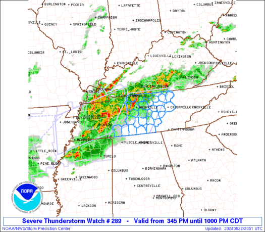
SPC Severe Thunderstorm Watch 289
WW 289 SEVERE TSTM NE WY 082055Z - 090300Z


URGENT - IMMEDIATE BROADCAST REQUESTED
Severe Thunderstorm Watch Number 289
NWS Storm Prediction Center Norman OK
255 PM MDT Mon Jun 8 2026

The NWS Storm Prediction Center has issued a

* Severe Thunderstorm Watch for portions of
  Nebraska Panhandle
  Southeast Wyoming

* Effective this Monday afternoon and evening from 255 PM until
  900 PM MDT.

* Primary threats include...
  Scattered large hail and isolated very large hail events to 2
    inches in diameter possible
  Scattered damaging wind gusts to 70 mph possible

SUMMARY...A few severe thunderstorms are forecast to develop through
the remainder of the afternoon and persist into the evening as this
activity moves generally west to east over the Watch area.  Large
hail and severe gusts will be the primary severe hazards with the
stronger thunderstorms.

The severe thunderstorm watch area is approximately along and 50
statute miles north and south of a line from 30 miles southwest of
Torrington WY to 25 miles south of Alliance NE. For a complete
depiction of the watch see the associated watch outline update
(WOUS64 KWNS WOU9).

PRECAUTIONARY/PREPAREDNESS ACTIONS...

REMEMBER...A Severe Thunderstorm Watch means conditions are
favorable for severe thunderstorms in and close to the watch area.
Persons in these areas should be on the lookout for threatening
weather conditions and listen for later statements and possible
warnings. Severe thunderstorms can and occasionally do produce
tornadoes.

&&

OTHER WATCH INFORMATION...CONTINUE...WW 287...WW 288...

AVIATION...A few severe thunderstorms with hail surface and aloft to
2 inches. Extreme turbulence and surface wind gusts to 60 knots. A
few cumulonimbi with maximum tops to 450. Mean storm motion vector
26010.

...Smith


Read more
SPC Tornado Watch 288
WW 288 TORNADO CO KS NE 082030Z - 090300Z


URGENT - IMMEDIATE BROADCAST REQUESTED
Tornado Watch Number 288
NWS Storm Prediction Center Norman OK
230 PM MDT Mon Jun 8 2026

The NWS Storm Prediction Center has issued a

* Tornado Watch for portions of
  Northeast Colorado
  Far Northwest Kansas
  Far Southwest Nebraska

* Effective this Monday afternoon and evening from 230 PM until
  900 PM MDT.

* Primary threats include...
  A couple tornadoes possible
  Scattered large hail and isolated very large hail events to 4
    inches in diameter likely
  Scattered damaging winds and isolated significant gusts to 75
    mph possible

SUMMARY...Isolated to scattered severe thunderstorms are forecast to
develop this afternoon and evening.  The stronger storms will likely
become supercellular and pose a risk for a couple of tornadoes,
large to giant hail (1 to 4 inches in diameter), and severe gusts.
Some clustering of storms is possible later this evening with the
severe wind threat becoming more prevalent, but a lingering risk for
large hail and a tornado may continue with any surface-based
supercell.

The tornado watch area is approximately along and 60 statute miles
north and south of a line from 10 miles northwest of Denver CO to 25
miles north northeast of Goodland KS. For a complete depiction of
the watch see the associated watch outline update (WOUS64 KWNS
WOU8).

PRECAUTIONARY/PREPAREDNESS ACTIONS...

REMEMBER...A Tornado Watch means conditions are favorable for
tornadoes and severe thunderstorms in and close to the watch
area. Persons in these areas should be on the lookout for
threatening weather conditions and listen for later statements
and possible warnings.

&&

OTHER WATCH INFORMATION...CONTINUE...WW 287...

AVIATION...Tornadoes and a few severe thunderstorms with hail
surface and aloft to 4 inches. Extreme turbulence and surface wind
gusts to 65 knots. A few cumulonimbi with maximum tops to 500. Mean
storm motion vector 26015.

...Smith


Read more
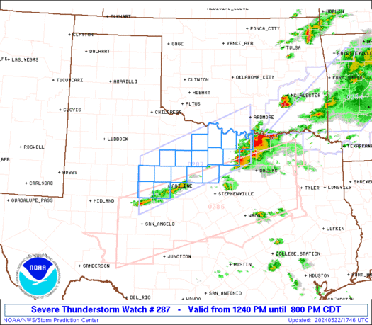
SPC Tornado Watch 287
WW 287 TORNADO KS NE 082010Z - 090300Z


URGENT - IMMEDIATE BROADCAST REQUESTED
Tornado Watch Number 287
NWS Storm Prediction Center Norman OK
310 PM CDT Mon Jun 8 2026

The NWS Storm Prediction Center has issued a

* Tornado Watch for portions of
  Northern into Central Kansas
  Southern Nebraska

* Effective this Monday afternoon and evening from 310 PM until
  1000 PM CDT.

* Primary threats include...
  A couple tornadoes possible
  Widespread damaging winds and isolated significant gusts to 90
    mph likely
  Scattered large hail and isolated very large hail events to 4
    inches in diameter likely

SUMMARY...Isolated to scattered supercells are forecast to develop
and intensify this afternoon into the early evening.  Large to giant
hail will be possible with the supercells.  A tornado risk with the
possibility for a couple of tornadoes will seemingly develop later
this afternoon into the early evening coincident with perhaps some
enhancement of low-level shear.  Upscale growth into a severe linear
cluster is forecast to eventually evolve this evening with severe
gusts becoming more prevalent.  Significant severe gusts ranging
from 75-90 mph are possible this evening as this storm evolution
occurs.

The tornado watch area is approximately along and 60 statute miles
north and south of a line from 25 miles south of Mccook NE to 55
miles east northeast of Russell KS. For a complete depiction of the
watch see the associated watch outline update (WOUS64 KWNS WOU7).

PRECAUTIONARY/PREPAREDNESS ACTIONS...

REMEMBER...A Tornado Watch means conditions are favorable for
tornadoes and severe thunderstorms in and close to the watch
area. Persons in these areas should be on the lookout for
threatening weather conditions and listen for later statements
and possible warnings.

&&

AVIATION...Tornadoes and a few severe thunderstorms with hail
surface and aloft to 4 inches. Extreme turbulence and surface wind
gusts to 80 knots. A few cumulonimbi with maximum tops to 550. Mean
storm motion vector 28010.

...Smith


Read more
SPC Severe Thunderstorm Watch 291 Status Reports
WW 0291 Status Updates


STATUS FOR WATCH 0291 HAS NOT BEEN ISSUED YET

Read more
SPC Severe Thunderstorm Watch 290 Status Reports
WW 0290 Status Updates


STATUS REPORT ON WW 290

SEVERE WEATHER THREAT CONTINUES RIGHT OF A LINE FROM 15 W CNK TO
10 NNE FLV.

..LYONS..06/09/26

ATTN...WFO...TOP...ICT...


STATUS REPORT FOR WS 290

SEVERE WEATHER THREAT CONTINUES FOR THE FOLLOWING AREAS

KSC003-015-017-027-029-031-041-045-059-061-073-079-085-087-111-
113-115-127-139-143-149-155-161-169-173-177-197-090340-

KS
.    KANSAS COUNTIES INCLUDED ARE

ANDERSON             BUTLER              CHASE
CLAY                 CLOUD               COFFEY
DICKINSON            DOUGLAS             FRANKLIN
GEARY                GREENWOOD           HARVEY
JACKSON              JEFFERSON           LYON
MCPHERSON            MARION              MORRIS
OSAGE                OTTAWA              POTTAWATOMIE
RENO                 RILEY               SALINE
SEDGWICK             SHAWNEE             WABAUNSEE


THE WATCH STATUS MESSAGE IS FOR GUIDANCE PURPOSES ONLY.  PLEASE
REFER TO WATCH COUNTY NOTIFICATION STATEMENTS FOR OFFICIAL
INFORMATION ON COUNTIES...INDEPENDENT CITIES AND MARINE ZONES
CLEARED FROM SEVERE THUNDERSTORM AND TORNADO WATCHES.


Read more
SPC Severe Thunderstorm Watch 289 Status Reports
WW 0289 Status Updates


STATUS REPORT ON WW 289

SEVERE WEATHER THREAT CONTINUES RIGHT OF A LINE FROM 25 SSE CYS
TO 35 SSW TOR TO 45 E DGW.

..THORNTON..06/09/26

ATTN...WFO...CYS...


STATUS REPORT FOR WS 289

SEVERE WEATHER THREAT CONTINUES FOR THE FOLLOWING AREAS

NEC007-013-033-105-123-157-165-090240-

NE
.    NEBRASKA COUNTIES INCLUDED ARE

BANNER               BOX BUTTE           CHEYENNE
KIMBALL              MORRILL             SCOTTS BLUFF
SIOUX


WYC015-090240-

WY
.    WYOMING COUNTIES INCLUDED ARE

GOSHEN


THE WATCH STATUS MESSAGE IS FOR GUIDANCE PURPOSES ONLY.  PLEASE
REFER TO WATCH COUNTY NOTIFICATION STATEMENTS FOR OFFICIAL
INFORMATION ON COUNTIES...INDEPENDENT CITIES AND MARINE ZONES
CLEARED FROM SEVERE THUNDERSTORM AND TORNADO WATCHES.


Read more
SPC Tornado Watch 288 Status Reports
WW 0288 Status Updates


STATUS REPORT ON WW 288

SEVERE WEATHER THREAT CONTINUES RIGHT OF A LINE FROM 10 ENE COS
TO 35 NW LIC TO 25 SSE AKO TO 20 SW SNY.

FOR ADDITIONAL INFORMATION SEE MESOSCALE DISCUSSION 1037

..THORNTON..06/09/26

ATTN...WFO...BOU...GLD...


STATUS REPORT FOR WT 288

SEVERE WEATHER THREAT CONTINUES FOR THE FOLLOWING AREAS

COC017-039-063-073-125-090240-

CO
.    COLORADO COUNTIES INCLUDED ARE

CHEYENNE             ELBERT              KIT CARSON
LINCOLN              YUMA


KSC023-181-199-090240-

KS
.    KANSAS COUNTIES INCLUDED ARE

CHEYENNE             SHERMAN             WALLACE


NEC057-090240-

NE
.    NEBRASKA COUNTIES INCLUDED ARE

DUNDY

Read more
SPC Tornado Watch 287 Status Reports
WW 0287 Status Updates


STATUS REPORT ON WW 287

SEVERE WEATHER THREAT CONTINUES RIGHT OF A LINE FROM 40 SSW HLC
TO 45 SSW HSI.

..LYONS..06/09/26

ATTN...WFO...ICT...GLD...DDC...GID...


STATUS REPORT FOR WT 287

SEVERE WEATHER THREAT CONTINUES FOR THE FOLLOWING AREAS

KSC009-051-053-089-105-123-141-153-159-163-167-183-193-195-
090140-

KS
.    KANSAS COUNTIES INCLUDED ARE

BARTON               ELLIS               ELLSWORTH
JEWELL               LINCOLN             MITCHELL
OSBORNE              RAWLINS             RICE
ROOKS                RUSSELL             SMITH
THOMAS               TREGO


NEC087-090140-

NE
.    NEBRASKA COUNTIES INCLUDED ARE

HITCHCOCK


THE WATCH STATUS MESSAGE IS FOR GUIDANCE PURPOSES ONLY.  PLEASE
REFER TO WATCH COUNTY NOTIFICATION STATEMENTS FOR OFFICIAL
INFORMATION ON COUNTIES...INDEPENDENT CITIES AND MARINE ZONES
CLEARED FROM SEVERE THUNDERSTORM AND TORNADO WATCHES.

Read more
SPC MD 1039
MD 1039 CONCERNING SEVERE THUNDERSTORM WATCH 290... FOR PORTIONS OF CENTRAL KS


Mesoscale Discussion 1039
NWS Storm Prediction Center Norman OK
0944 PM CDT Mon Jun 08 2026

Areas affected...portions of central KS

Concerning...Severe Thunderstorm Watch 290...

Valid 090244Z - 090345Z

The severe weather threat for Severe Thunderstorm Watch 290
continues.

SUMMARY...Significant severe gusts of 100+ mph have occurred and may
continue downstream of an intense bowing segment and merging
supercell over the next hour.

DISCUSSION...Recent radar and surface observations of the bowing
complex across Saline and Dickinson Counties in KS show significant
severe wind gust potential. The environment is extremely unstable
and supportive of gusts over 100 mph.

An internal surge within the bowing segment recently produced a
measured 113 mph gust at KSLN. Additional significant gusts of 100+
mph are possible where a supercell is interacting with the gust
front near the Saline/Dickinson county line. The significant wind
threat may continue over the next hour as the bowing complex surges
southeastward.

..Lyons.. 06/09/2026

...Please see www.spc.noaa.gov for graphic product...

ATTN...WFO...TOP...ICT...

LAT...LON   38849741 39049716 38919672 38789645 38479625 38419624
            38319629 38169669 38259723 38409772 38519776 38599758
            38849741

MOST PROBABLE PEAK TORNADO INTENSITY...100-125 MPH
MOST PROBABLE PEAK WIND GUST...85-100 MPH
MOST PROBABLE PEAK HAIL SIZE...1.50-2.50 IN


Read more
SPC MD 1038
MD 1038 CONCERNING SEVERE THUNDERSTORM WATCH 290... FOR CENTRAL AND EASTERN KANSAS

Mesoscale Discussion 1038
NWS Storm Prediction Center Norman OK
0855 PM CDT Mon Jun 08 2026

Areas affected...central and eastern Kansas

Concerning...Severe Thunderstorm Watch 290...

Valid 090155Z - 090400Z

The severe weather threat for Severe Thunderstorm Watch 290
continues.

SUMMARY...An evolving thunderstorm complex will move southeastward
with a risk for severe gusts this evening.

DISCUSSION...Ongoing convection over Tornado Watch 287 and Severe
Watch 290 has grown upscale into an organized and linear convective
complex this evening. Further upscale growth is likely as the
cluster interacts with a very unstable environment (MLCAPE 4000+
J/kg) and a 25-35 kt southerly low-level jet. The strong instability
and cold pool will likely support severe gusts through this evening.
A few significant gusts to 75+ mph are also possible.

Observed low-level shear is also fairly strong from the ICT VAD
(0-1km SRH of 100-200 m2/s2). This could support a couple of
tornadoes, both with the linear cluster, and with interacting cells
ahead of the outflow. With the complex expected to continue
east/southeast, the risk for severe wind gusts remains high across
WW290.

..Lyons.. 06/09/2026

...Please see www.spc.noaa.gov for graphic product...

ATTN...WFO...TOP...ICT...GID...DDC...

LAT...LON   37509528 37379582 37609725 37909812 38249873 38669890
            39139889 39589816 39729738 39589629 39369573 39019520
            38059508 37679517 37509528

MOST PROBABLE PEAK TORNADO INTENSITY...85-110 MPH
MOST PROBABLE PEAK WIND GUST...75-90 MPH
MOST PROBABLE PEAK HAIL SIZE...1.50-2.50 IN
Read more
SPC MD 1037
MD 1037 CONCERNING SEVERE POTENTIAL...WATCH POSSIBLE FOR WESTERN/CENTRAL NEBRASKA INTO NORTHERN KANSAS

Mesoscale Discussion 1037
NWS Storm Prediction Center Norman OK
0758 PM CDT Mon Jun 08 2026

Areas affected...western/central Nebraska into northern Kansas

Concerning...Severe potential...Watch possible

Valid 090058Z - 090300Z

Probability of Watch Issuance...60 percent

SUMMARY...Damaging wind potential to evolve downstream through the
evening.

DISCUSSION...One or more clusters of thunderstorms will move
downstream into portions of western and central Nebraska into far
northern Kansas this evening. Surface objective analysis suggests
MLCIN is in place across portions of central Nebraska, with
temperatures cooling with the diurnal cycle. THe 00z sounding from
LBF further supports this notion with a warm nose around 850-700 mb.
With loss of heating, it is likely MLCIN will remain, which may
temper the downstream severe risk with northern extent.

A more well defined cluster coming out of eastern Colorado may
present the more likely severe potential into the evening.
Downstream across southern Nebraska into northern Kansas, MLCIN
weakens with a steep gradient of MLCAPE around 1000-4000 J/kg
extending into north-central Kansas. Additionally, strong deep layer
shear is in place which should foster organization of a damaging MCS
this evening.

A new Severe Thunderstorm watch may be possible to replace portions
of Tornado Watches 288 and 287 by 03z.

..Thornton/Gleason.. 06/09/2026

...Please see www.spc.noaa.gov for graphic product...

ATTN...WFO...LBF...GLD...BOU...CYS...

LAT...LON   39980350 40700335 41690333 41850329 42020325 42450266
            42380137 42070105 41840092 41540081 40690065 40320066
            39930076 39650088 39430125 39310148 39310214 39350225
            39350294 39420341 39630341 39980350

MOST PROBABLE PEAK TORNADO INTENSITY...85-110 MPH
MOST PROBABLE PEAK WIND GUST...65-80 MPH
MOST PROBABLE PEAK HAIL SIZE...1.50-2.50 IN
Read more
SPC Jun 9, 2026 0100 UTC Day 1 Convective Outlook
SPC 0100Z Day 1 Outlook


Day 1 Convective Outlook
NWS Storm Prediction Center Norman OK
0805 PM CDT Mon Jun 08 2026

Valid 090100Z - 091200Z

...THERE IS AN ENHANCED RISK OF SEVERE THUNDERSTORMS ACROSS PARTS OF
THE CENTRAL PLAINS...

...SUMMARY...
Severe thunderstorms with large to very large hail, damaging wind
gusts and a couple of tornadoes are likely this evening from parts
of northeastern Colorado into northwestern Kansas. Large to very
large hail, severe wind gusts from 60 to 90 mph, and a tornado
threat are likely this evening across parts of north-central and
eastern Kansas. An isolated severe threat may persist for a couple
more hours from the eastern Texas Panhandle into northwestern
Oklahoma.

...Northeast Colorado/Northwest Kansas...
A mid-level shortwave trough, evident on water vapor imagery, is
currently moving northeastward across northeast Colorado. At the
surface, a front is located across eastern Colorado with a moist
airmass extending from northeastern Colorado southeastward into
western Kansas. Surface dewpoints along this corridor range from the
upper 50s to the mid 60s F, which is contributing to moderate to
strong instability. Scattered severe thunderstorms are ongoing
across northeastern Colorado along the western edge of the stronger
instability, and further north into far southeast Wyoming and
western Nebraska. The storms are expected to organize into a line
and move east-southeastward into southwestern Nebraska and
northwestern Kansas this evening. Large to very large hail will be
possible with the more intense supercells over the next hour or two,
mainly along the southern end of the line where some cells are
likely to remain discrete. Hailstones up to 3 inches in diameter
will be possible. A couple tornadoes will also be possible with
supercells. As a transition to linear mode occurs, the wind-damage
threat will increase. Wind gusts above 75 mph will be possible near
the leading edge of any bowing segments.

...North-central and Eastern Kansas...
On water vapor imagery, a subtle shortwave trough appears to be
located from southern Nebraska southward into central Kansas. Ahead
of this feature, a pocket of strong instability is analyzed by the
RAP over south-central Kansas, where MLCAPE is estimated to be in
the 4000 to 5000 J/kg range. A line of severe storms is ongoing in
north-central Kansas, to the north-northwest of the instability
maximum. Multiple supercells with potential for large to very large
hail are ongoing within this line. Over the next couple of hours,
this line is expected to organize into a bowing segment, moving
east-southeastward across the remainder of north-central Kansas and
into eastern Kansas later this evening. The instability combined
with 30 to 40 knots of 0-6 km shear, and steep mid-level lapse rates
near 8 C/km will support a wind-damage threat. If a bowing line
segment can become intense later this evening, a potential will
exist for significant wind gusts above 80 mph. The wind-damage
threat will likely impact far eastern Kansas later this evening, and
western Missouri after midnight. A secondary line of thunderstorms
with severe wind gusts is expected to impact parts of north-central
Kansas after midnight.

...Eastern Texas Panhandle/Northwestern Oklahoma...
A very moist and unstable airmass is located across the southern
Plains. Surface dewpoints from the eastern Texas Panhandle into
northwestern Oklahoma are in the mid 60s to lower 70s F. This is
contributing to strong instability with the RAP showing MLCAPE in
the 3000 to 3500 J/kg range, with steep low-level lapse rates. The
thermodynamic environment should support an isolated threat for
severe wind gusts for a couple more hours this evening...see MCD
1036.

...Far Western Kentucky...
A bowing line segment is currently ongoing in far western Kentucky
along an axis of moderate instability, where the RAP has MLCAPE near
2000 J/kg. RAP forecast soundings to the south of Paducah have 0-3
km storm-relative helicity around 200 m2/s2 early this evening,
suggesting that an isolated tornado threat may persist for another
hour or two. A few strong wind gusts will also be possible.

..Broyles.. 06/09/2026


Read more
SPC Day 3-8 Fire Weather Outlook
SPC Day 3-8 Fire Weather Outlook


Day 3-8 Fire Weather Outlook
NWS Storm Prediction Center Norman OK
0455 PM CDT Mon Jun 08 2026

Valid 101200Z - 161200Z

...Synopsis...
A large scale upper trough will gradually shift eastward from the
Northern Rockies on Day 3/Wednesday into the Great Lakes by Day
5/Friday. A troughing pattern will likely remain entrenched across
Ontario Canada and northeastern U.S. with another possible short
wave pushing southeastward into the Northern Rockies early next
week. The departing trough and accompanying stronger mid-level flow
will subdue broader fire weather concerns across the West later this
week as the amplifying ridge promotes a warming and drying trend
across the region.

...Day 3-5/Wednesday-Friday...
...Eastern Great Basin, Colorado Plateau and central High Plains...
Stronger westerly surface winds in the wake of a cold front below a
pronounced 80-90 knot mid-level jet, will likely bring an enhanced
fire weather concern to portions of southeastern WY and western NE
Panhandle on Day 3/Wednesday. 70% critical probabilities have been
introduced where west winds of 25-30 mph and RH as low as 15% align
with pockets of dry fuels. Weaker but still impactful westerly flow
will bring a fire weather concern to much of the eastern Great
Basin, Colorado Plateau and Four corners regions where 40%
probabilities remain. The broader fire weather threat contracts
towards the Four Corners and adjacent southern CO Rockies by Days
4-5/Thursday-Friday as influence from the departing upper trough and
surface pressure features begins to wane.

...Sacramento Valley...
Dry, post-frontal northerly flow funneling into the Sacramento
Valley will likely promote an enhanced fire weather threat for this
region and adjacent valley foothills beginning Day 3/Wednesday,
lingering into Day 4/Thursday. North winds of 10 to locally 20 mph,
RH at or below 15% are expected to combine with receptive fuels to
support fire spread. 40% critical probabilities were added for Day
4/Thursday accounting for latest model guidance and duration of
event.

...Day 6/Saturday...
...Northern Arizona and Southern Utah...
A weak upper trough west of Baja Peninsula will aid in northward
transport of deeper Pacific moisture from Tropical Storm Boris
through the week, reaching the lower desert areas of the Southwest
as early as Day 5/Friday. Precipitable water values of one inch or
more should stay south of the Mogollon Rim region through the
weekend. A dry thunderstorm concern will likely exist on the fringes
of the deeper moisture across northern AZ into southern UT. A 10%
probability dry thunderstorm area was introduced, although some
modifications may be needed in subsequent outlooks as forecast
certainty increases.

..Williams.. 06/08/2026

...Please see www.spc.noaa.gov/fire for graphic product...


Read more